If you are up for a challenge and love hiking then the Angelus Hut may be your next target! With a choice of four different routes and plenty of obstacles to overcome, this 2-3 day climb is perfect for those looking to push themselves and admire some of New Zealand’s spectacular scenery! Add to your stack today to jump-start your next adventure!
What can I expect from the Angelus Hut?
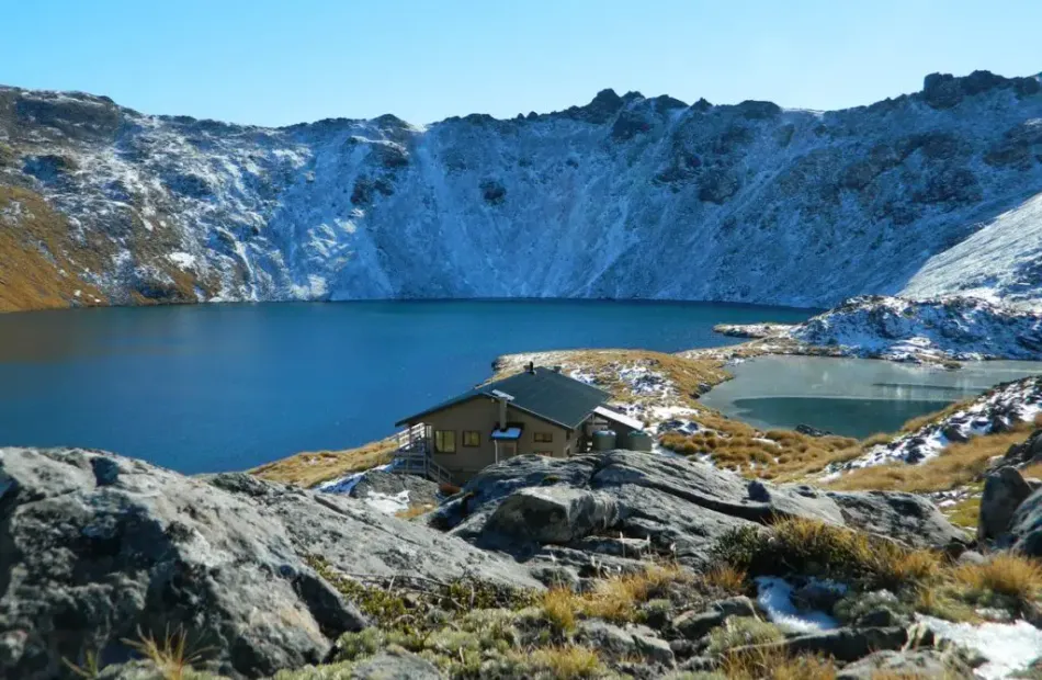
The Angelus Hut is located at an altitude of 1,650 metres on the shores of Lake Angelus and is surrounded by stunning views of the nearby mountains!
When setting off on you’re journey to the hut, there are 4 different trails and routes you can choose from! Each of the routes is viable depending on the weather and overall conditions at the time of your journey. The four routes are as follows:
The first option is the Pinchgut Track, Robert Ridge Route. This is the most popular trail to follow in fine weather but expect ice and snow during the winter and spring. Make sure to take care on this route as there are exposed ridge sections that are vulnerable to high winds and low visibility!
Another trail you can follow is the Speargrass Track, Speargrass Creek Route! This path is most commonly used when exiting Lake Angelus when the weather isn’t the best. There are some stream crossings and the trail is marked along the way with posts for when visibility is low. Make sure to wear appropriate footwear as there are some muddy sections below the edge of the bush.
The third choice of routes is the Travers – Cascade Track. On this route, you can expect snow and ice during the winter and spring. This route is also marked along the way with posts and cairns for when visibility isn’t ideal. Take into consideration that from May to November, the bridge over the Hukere Stream is unavailable due to the risk of avalanches. Take care if you are on this route after rain and during the melting of snow as crossing the river is a bit trickier.
Finally, there is the Mt Cedric Track. This route is only used by trampers that are heading to the hut via the Travers – Sabine Circuit. There is no water on this route and you can expect ice and snow during the winter and spring. Take care as the trail is a steep climb and includes a very exposed ridge that is susceptible to high winds and a lack of visibility.
- The hut includes 28 bunk beds, heating, toilets, and running water (needs to be boiled before use)
- Hikers on these trails must be fit enough for a 2-3 day-long journey of up to 12km for 6 hours each day and fit enough to climb 1,800 metres
- Please only make the journey if you are comfortable on rough terrain okay with heights
- For information on where to start off your walk, please take a look at the map on the featured website
 23 miles